
Travel video guide
Where to Eat in Schönau am Königssee: Fischer Kuchen
This guide turns The 7 Most Beautiful Hikes in the Bavarian Alps from marlenesleben into a practical food map with 12 saved spots around Schönau am Königssee, Am Obstgarten, and Archenkanzel. The mapped places include a mountain peak, a place marker, a tourist attraction, and a hiking area. Use it to understand the places, dishes, and trip context before saving the map in Varedelo.
What the creator captured
marlenesleben showcases their favorite hiking tours in the Bavarian Alps, ranging from relaxed lakeside walks to challenging via ferratas. They highlight the Archenkanzel via the Rinnendelsteig as a bucket-list experience for its breathtaking views over Königssee. The creator emphasizes the diversity of the region, from deep gorges and waterfalls to high-altitude alpine huts.
What this map is good for
- Planning a tourist attraction stop or short itinerary in Schönau am Königssee.
- Comparing food stops from a creator or saved local map before you commit time in the city.
- Saving 12 mapped spots into Varedelo so the list stays usable on the ground.
- Using the original video as context, then turning it into a clean place-by-place map.
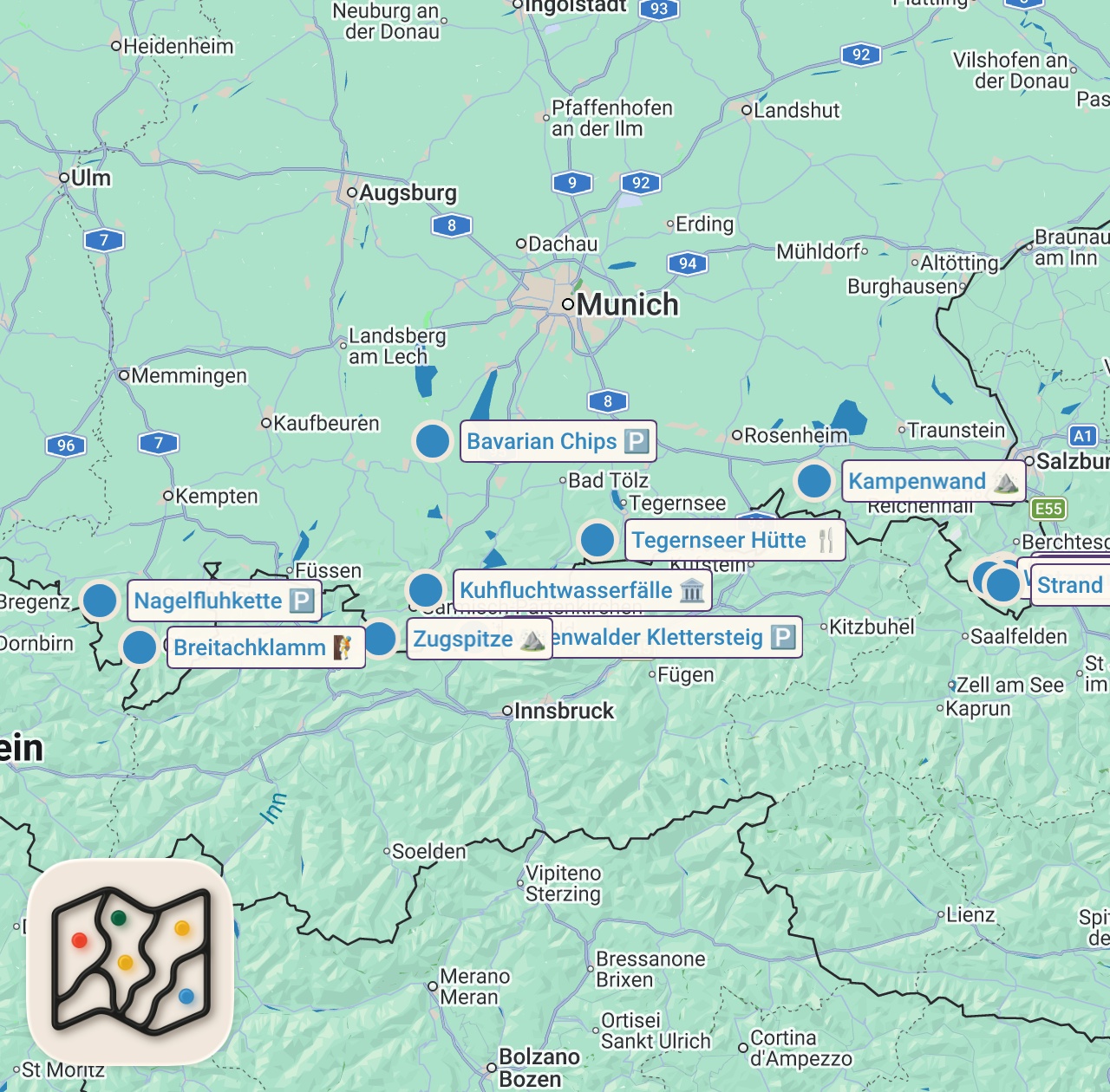
Featured spots on this map
- Kuhfluchtwasserfälle
Tourist Attraction in Kuhfluchtweg, 82490 Farchant, Germany, Kuhfluchtweg, Farchant, Germany
Hours: Hours available - Archenkanzel
Mountain Peak in Archenkanzel, 83471 Schönau am Königssee, Germany, Archenkanzel, Schönau am Königssee, Germany - Zugspitze
Mountain Peak in Zugspitze - Watzmann
Tourist Attraction in Watzmann, 83471 Schönau am Königssee, Germany, Watzmann, Schönau am Königssee, Germany - Nagelfluhkette
Place marker in Nagelfluhkette, 87534 Oberstaufen, Germany, Nagelfluhkette, Oberstaufen, Germany - Breitachklamm
Hiking Area in Klammstraße 47, 87561 Oberstdorf, Germany, Oberallgäu, Oberstdorf, Bayern, Germany
Hours: Hours available - Bavarian Chips
Place marker in Am Obstgarten 12, 82362 Weilheim in Oberbayern, Germany, Am Obstgarten, Weilheim in Oberbayern, Germany - Königssee
Lake in Königssee, 83471 Schönau am Königssee, Germany, Berchtesgadener Land, Schönau am Königssee, Bavaria, Germany - Strand bei St.Bartolomä
Tourist Attraction in Unnamed Road,83471, 83471 Schönau am Königssee, Germany, Schönau am Königssee, Germany
Hours: Hours available - Tegernseer Hütte
Restaurant in Berghaus 20, 83708 Kreuth, Germany, Berghaus, Kreuth, Germany - Kampenwand
Mountain Peak in Kampenwand, 83229 Aschau im Chiemgau, Germany, Kampenwand, Aschau im Chiemgau, Germany - Mittenwalder Klettersteig
Place marker in Mittenwalder Klettersteig, Mittenwald, Germany, Mittenwalder Klettersteig, Mittenwald, Germany
Food notes from the video
- Fischer Kuchen
- Weißwürste mit Brezen
- Salat mit Wienerle
- Hausgemachter Kuchen
Experiences captured
- Walked through Breitachklamm, Germany's deepest gorge
- Hiked to the spectacular Tegernseer Hütte
- Walked the 7.5 km loop around Eibsee
- Crossed the airy Mittenwalder Höhenweg via ferrata
- Visited the family-friendly Kuhflucht waterfalls
- Climbed to the summit of Kampenwand
- Hiked the Nagelfluhkette alpine pasture trail
- Took a boat to St. Bartholomä at Königssee
Official tourism resource
The official tourism portal for Schönau am Königssee, providing information on accommodations, activities, and attractions in the Berchtesgaden National Park.
Planning questions
Where did marlenesleben eat in Schönau am Königssee?
This guide maps all 12 spots featured in the video, with names, addresses, and neighborhoods, so you can plan where to eat in Schönau am Königssee.
What are the must-try foods in Schönau am Königssee?
Creator picks from the video include Fischer Kuchen, Weißwürste mit Brezen, Salat mit Wienerle, Hausgemachter Kuchen. Open the map in Varedelo to see which spot each one is at.
Can I save these spots to use on my trip?
Yes. Open the map in Varedelo to save every spot, get directions, and revisit the guide from your phone while you travel.
Use it on your trip
Save this food map before you go
Keep the mapped spots, creator context, food notes, and planning details together. Varedelo turns the page into a phone-friendly map you can revisit when you are choosing where to go.